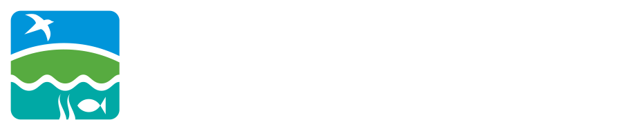
Meet the newest member of the Soundkeeper Team – the Phantom Pro 4. In the past few years, small drones have become extremely popular among hobbyists as well as scientists and engineers. While there’s a lot of discussion to be had about the use of hobby drones, we are exploring their potential in monitoring the progress of ecological restoration. Automated flight patterns, multi-image rendering, and the ability to take videos are all extremely useful tools that expand the breadth with which we can survey and monitor these sites. For example, collecting information about changing plant communities in a dam removal project, using infrared cameras to track pollution sources, or measuring the growth of restored oyster reefs.
Mapping Out Changing Plant Communities
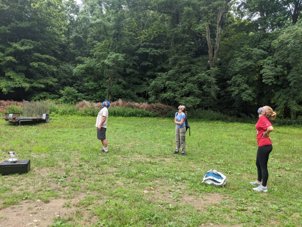
Recently, Soundkeeper Bill Lucey brought the drone out to Merwin Meadows Park in Wilton, Connecticut. The Norwalk River runs through Merwin Meadows before emptying out into the Long Island Sound eight miles downriver. The Dana Dam, also known as the Strong Pond Dam or Merwin Meadows Dam, has been blocking sea-run fish and affecting sediment flow for decades. The pond behind the dam is filled with mud and creates a heat sink in the summer releasing hot water to the Norwalk River becoming a “thermal barrier” to cold water species like trout. Because of this, the dam at Merwin Meadows is a prime target for removal. Though structurally sound, the dam removal will help restore the natural sediment flow and water temperatures to this portion of the river, as well as open up several miles of habitat to migratory fish species.
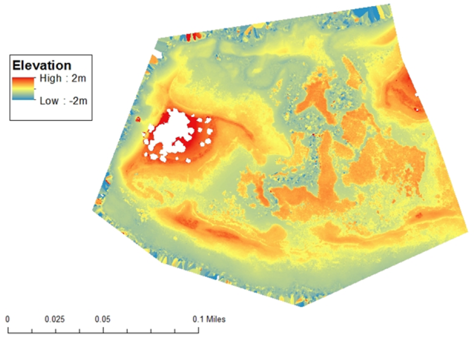
When it comes to monitoring ecological changes due to dam removal, the first step is mapping out the current conditions. The drone records altitude and can create a “Digital Elevation Model” which depicts the topography of the project area (insert picture). Alterations to sediment flow and water level, as well as some other factors, can have significant effects on the species of plants that grow in a certain area. Determining what currently exists and the plants that recolonize the pond sediment after removal can help us collect information on how dam removal will affect different plant communities, including invasive species, in future projects.
From there, it becomes important to take regular aerial images of the immediate area to monitor changes. While this is possible to do in person, using the drone can save a significant amount of work hours. The high resolution renderings can be as precise two square centimeters per pixel, allowing Bill and the ecological restoration team to take high quality data on these changing plant communities and monitor riverine responses to the barrier removal. Read more about the Dana Dam removal project here.
Tracking Pollution Sources
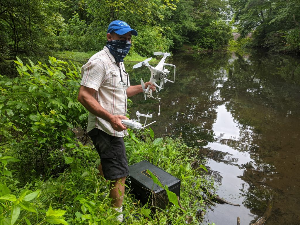
The Phantom Pro 4 is equipped with a selection of remote sensing devices. Not only can it take regular pictures, but it can capture digital elevation models, infrared images, and more. The infrared cameras specifically can be used to create heat maps of different rivers, identifying which portions are experiencing unnatural or unusual amounts of heat. Sometimes this heat can be tied to leaky sewage pipes, since sewage tends to be warmer than winter waters of Long Island Sound, these surveys are best conducted in the cold months. It could also be tied to heat discharge from factories or other industry. Many people think of chemicals or trash when thinking about water pollution, but heat alone can act as a pollutant as well. It may encourage the growth of harmful algae, create temperature barriers for fish trying to move up and down river, and affect oxygen concentrations in the water. A typical pollution patrol involves Bill traveling along the shores of the sound, keeping his eyes and nose on the coastline looking for signs of sewage or industrial discharge. Using drones can help expand the area that can be surveyed in a certain time frame and also provides quantitative data on heat signatures along the rivers and coastline of Long Island Sound.
Soundkeeper began his UAV training in Hawaii where thermal cameras were used to track lava flows and locate places where groundwater was contaminated with nitrogen from cesspools. Locating sources of groundwater discharge is more difficult than outfalls and rivers so thermal imaging may assist locating previously hidden contamination sources.
Examining Groundwater and Surface Water Interactions to Determine the Effects of Anthropogenic Nutrient Loading on Streams and Coastal Water Quality. Michael R. Mathioudakis, Craig R. Glenn, Daniel E. Dores. University of Hawai‘i at Mānoa, Department of Geology and Geophysics 2018
Measuring Growth of Oyster Reef Restoration Sites
Save the Sound has been working with the City Island Oyster Reef Project to plan and execute the construction of oyster restoration sites around City Island in the Bronx. Located in the Western Sound, this area experiences pollution from storm water runoff and combined sewer overflows in New York City. Adult oysters can filter as much as 50 gallons of water a day, collecting toxins and other contaminants and then locking them away in their shells. Organizations like the Billion Oyster Project have brought oyster reefs to the forefront of the discussion in the waters of New York. These reefs can clean our water as well as provide coastal stabilization, an important ecosystem service with the increasing frequency of large storms in the northeast.
How does the drone fit into this work? Reef aerial dimensions, or simply reef area, is one of the most important variables for assessing the progress of oyster restorations sites. As reefs become established, young oysters should grow larger while new oysters begin to contribute to the overall reef. Collecting images when the reef is first laid down and then every 3 months after is a simple but effective way to keep track of this. An accurate determination of reef aerial dimensions can help scientists quantify the amount of restored area, the reef persistence through time, the abundance of oysters, and the quantity of ecosystems services provided. Reef height is another variable we can measure, this time by using the digital elevation tool. While related to aerial dimensions, reef height can help us make inferences about the total amount of habitat available to fish in a given reef. In the past, researchers would have to map out these dimensions by taking a series of measurements from a boat or they would hire expensive contractors to survey the reefs for them. Increased access to drones has made this method of monitoring much more accessible for scientists in many different fields.
A Note on the Responsible Use of Drones
Personal drones are still relatively new technology. While they have become more affordable, giving access to drones to thousands of people, enforcement capacity has not caught up yet. There are rules and laws surrounding the use of drones, but without enforcement capacity it is up to the user to respect the safety and privacy of others. At Save the Sound we make a point to adhere to the following list of guidelines:
- Fly at or below 400 feet
- Keep the drone within sight
- Don’t fly in restricted airspace
- Don’t fly near other aircraft, especially near airports
- Don’t fly over groups of people
- Don’t fly over stadiums or sports events
- Don’t fly near emergency response efforts such as fires
- Don’t fly under the influence
We encourage all users of drones to follow these same guidelines, as well as local regulations, and respect the safety and privacy of others. Read more on the Federal Aviation Administration website.
Since the drone weighs more than 8.8 ounces, a Small Unmanned Aircraft System Certification is required: Bill Lucey – Remote Pilot Certification #4403478